
Saildrones are autonomous vehicles working in the ocean off the coast of Florida.They are helping us understand climate change, hurricanes and forecasting.Much of the destruction from hurricanes comes from the storm surge, but that’s difficult to predict.Advancements in storm surge forecasting could come with better information about the ocean floor.Hurricane winds aren’t the only thing that influences storms surge. Katrina was a Category 3 when it made landfall in Louisiana, but it had a 28-foot storm surge.The National Oceanic and Atmospheric Administration provided a map showing the inundation of a surge of 23 feet.NOAA estimates that in the Gulf and East Coast coastal communities, a surge of 23 feet can inundate 67% of interstates, almost half of all railroad tracks, 29 airports and virtually all ports in the Gulf Coast area.”The topography of the ocean bottom is a boundary condition for the models that are doing storm surge because essentially if there’s any type of change in the slope or if there are features on the bottom of the ocean, as that storm comes ashore and pushes the water, those features or that slope could really change how the water moves,” said Brian Connon, vice president of ocean mapping at Saildrone Inc.But only about 35% of the United States’ more than 95,000 miles of coastal waters have been mapped with modern methods.Now uncrewed surface vehicles call Saildrones are being used to map the ocean floor accurately and less expensively using high-tech sonar equipment.”A Saildrone is a unique, wind-propelled vehicle that is a very long endurance vehicle. So, traditionally surveys are done with a typical ship that goes out, has a lot of people on board, has a lot of diesel fuel that it’s burning. With a Saildrone, you don’t have the people. You’re using the wind for propulsion, and really, that makes this very environmentally friendly and gives us a very long endurance to stay out and reach the farthest parts of the ocean that allows us to map down to over 7,000 meters deep, so over 23,000 feet beneath the surface,” Connon said.Sonar is sound into the ocean.”The sound travels and hits the bottom of the ocean and then it comes back, and we receive it. And that time difference, by taking into account the speed of sound in water, that allows us to determine the depth of the water underneath of the sailboat,” Cannon said.Accurate ocean mapping can also help in navigation and managing natural resources, but there are hopes that it could help save lives with better storm surge forecasts.Watch the video above for the full story.
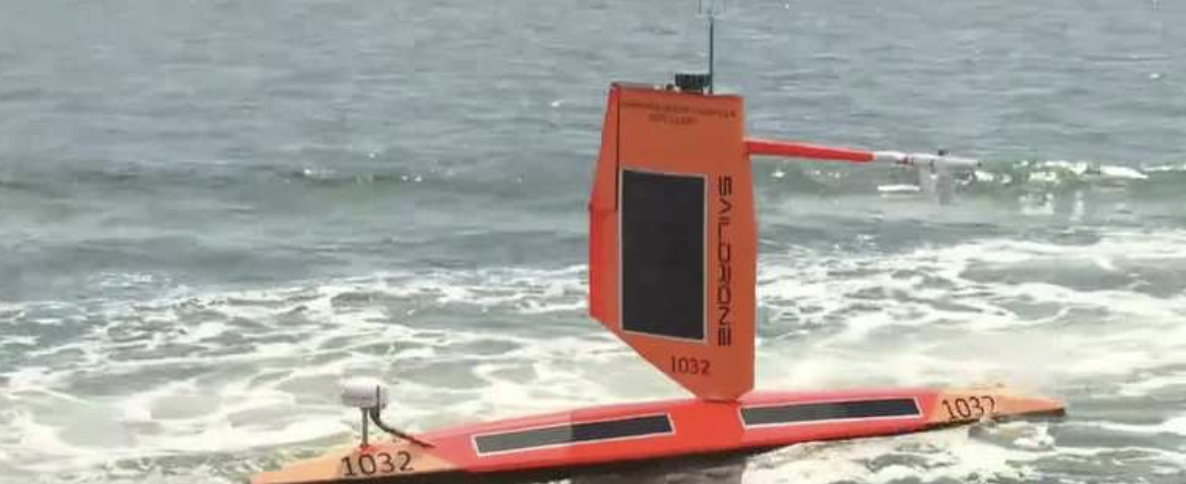
Saildrones are autonomous vehicles working in the ocean off the coast of Florida.
They are helping us understand climate change, hurricanes and forecasting.
Much of the destruction from hurricanes comes from the storm surge, but that’s difficult to predict.
Advancements in storm surge forecasting could come with better information about the ocean floor.
Hurricane winds aren’t the only thing that influences storms surge. Katrina was a Category 3 when it made landfall in Louisiana, but it had a 28-foot storm surge.
The National Oceanic and Atmospheric Administration provided a map showing the inundation of a surge of 23 feet.
NOAA estimates that in the Gulf and East Coast coastal communities, a surge of 23 feet can inundate 67% of interstates, almost half of all railroad tracks, 29 airports and virtually all ports in the Gulf Coast area.
“The topography of the ocean bottom is a boundary condition for the models that are doing storm surge because essentially if there’s any type of change in the slope or if there are features on the bottom of the ocean, as that storm comes ashore and pushes the water, those features or that slope could really change how the water moves,” said Brian Connon, vice president of ocean mapping at Saildrone Inc.
But only about 35% of the United States’ more than 95,000 miles of coastal waters have been mapped with modern methods.
Now uncrewed surface vehicles call Saildrones are being used to map the ocean floor accurately and less expensively using high-tech sonar equipment.
“A Saildrone is a unique, wind-propelled vehicle that is a very long endurance vehicle. So, traditionally surveys are done with a typical ship that goes out, has a lot of people on board, has a lot of diesel fuel that it’s burning. With a Saildrone, you don’t have the people. You’re using the wind for propulsion, and really, that makes this very environmentally friendly and gives us a very long endurance to stay out and reach the farthest parts of the ocean that allows us to map down to over 7,000 meters deep, so over 23,000 feet beneath the surface,” Connon said.
Sonar is sound into the ocean.
“The sound travels and hits the bottom of the ocean and then it comes back, and we receive it. And that time difference, by taking into account the speed of sound in water, that allows us to determine the depth of the water underneath of the sailboat,” Cannon said.
Accurate ocean mapping can also help in navigation and managing natural resources, but there are hopes that it could help save lives with better storm surge forecasts.
Watch the video above for the full story.
